Welcome to my Wilderness Journal

You may enjoy my September 2012 blog: Sharing Experiences of Great Mystery, which describes the purpose of this wilderness log, photo-art gallery, and poetry corner. In Peace, Bob

Saturday, December 21, 2019

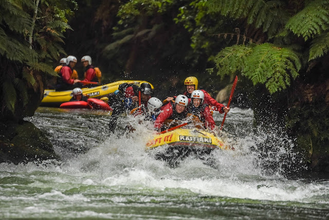
Going over the world's highest commercially-rafted waterfall


On the first day of December 2019, my wife and I donned a wetsuit, helmet, and lifevest at Kaitiaki Rafting near Rotorua, New Zealand to try something new and a bit scary. We entrusted our lives to the skill and experience of our Maori river guide Hemi to take us over the world's highest commercially-rafted plunge (21-feet) which is located on the Kaituna River. This was pretty easy because Hemi exuded enthusiasm and competence and he trained and coached us on what to do just before we had to do it. But in the end, you just have to "go with the flow" and see what happens. That's what an adventure is all about.

These photos tell the story of our beautiful adventure in sequence. [Note: If you click an image they enlarge and you can click/scroll through the photos. But you lose the text.]

We started out with some moderate whitewater to work us up to the big plunge.


Then a sideways slip down a small fall.


Then we approached the big Kahuna.


No turning back now!


My yellow helmet and three white ones are visible as we are engulfed by the waterfall.


Then we all disappear under the waves...


... to miraculously pop back up with the raft full of water.


At this point, we are stunned by the plunge and look a bit shocked.


But then we break out in smiles realizing we are still alive!


It was over in seconds but my entire life flashed before me! Hemi gives us the victory-peace sign.


We pose for the photographer. Hemi offers a friendly Maori "haka" tongue expression.


We made it over without flipping but the following raft was not so lucky (or were they the lucky ones since they survived it)! It was not the guide's fault. Curtis did everything right but they got caught in the falls.


One rafter falls out in the plunge.


Then a ton of falling water catches the edge of the raft and flips it.


All but two are now underwater or under the raft. I reach out to pull the first swimmer into our raft.


All's well that ends well! Happy rafter-swimmers in Curtis' craft.


Then it's more adventure. We try to stand up for the gentle drops.


Hemi goes completely airborne balanced on his paddle! Hemi is quite fit.


Then Hemi invites Tricia-Rose and me to assume the "Titanic" flying posture as he moves the raft into the waterfall face.


Tricia-Rose begins to disappear under the waters.


Then she is invisible!


Her left arm reappears.


... and is gone again. Hemi gives a "haka" tongue expression of approval.


Then we're both underwater but loving it! This was a great adventure and we're glad we did it. But maybe once is enough! Cheers!


Friday, December 20, 2019

Trekking New Zealand's Tongariro Alpine Crossing

Near the summit of Red Crater with Mt. Ngauruhoe

Considered one of the world's greatest day-hikes, I found North Island's Tongariro Alpine Crossing to be both majestic and challenging for this seventy-year-old. But since the average age of my fellow hikers was around thirty I felt great completing this 19.4-kilometer one-way trek in ten hours. Captivated by and photographing the volcanic landscape of glacial valleys, snow-covered peaks, old lava flows, craters, and fluorescent-hued lakes I managed to beat the last 6pm shuttle bus departure time by 3 minutes!

The trek is located at the heart of Tongariro National Park, which is both a natural and a cultural World Heritage Site. First, you climb from 1,120 meters up the Mangatepopo Valley to the saddle between the active volcanoes of Mt. Ngauruhoe (which was used as Mount Doom in the Lord of the Rings movies) and Mt. Tongariro. After lingering at the Soda Springs waterfall, I climbed the Devil's Staircase to cross the spectacular South Crater and then ascended to the trek's highpoint, the summit of Red Crater at 1,868 meters.

I then descended the steep and loose scree slope (falling once on the ball-bearing-like pumice) to the Emerald Lakes called Nga Rotopounamu (greenstone-hued lakes). Hikers are prohibited from touching these waters as they are sacred to the Maori people. This entire area is sacred to the Ngati Tuwharetoa, the local iwi or Maori tribe. In 1887 Te Hueheu Tukino, the chief of the Ngati Tuwharetoa had the generosity and foresight to work with the New Zealand government to create Tongariro National Park, the sixth national park in the world. When John Muir visited this area in 1904 he wrote that the three volcanic peaks in the park were "isolated temples and seem to have singular sacred significance... Each could possibly be a center of the world." I definitely felt the sacredness of this area. While crossing the huge expanse of South Crater I noticed I was walking in a subtle sea of white vapor no higher than my knees that was blowing alongside me and which disappeared as quickly as it appeared.

After crossing Central Crater I climbed to the rim of large Blue Lake, Te Wai Whakaata o Te Rangihiroa (Rangihiroa's mirror). Leaving the lake I was caught by a hailstorm which became a downpour. It was a long downhill trek through open alpine vegetation of low-growing herbs and tussock grasses. The rain stopped and I saw fumarole plumes of steam rising against the sky from the Te Maari craters which erupted in 2012. Then I entered the deep forest full of ferns and lichen-covered trees, rushing to make the last bus back to my hotel in National Park. I was one of the last people out.

The three volcanoes in the park form the western end of an extremely active volcanic zone that stretches northeast through Lake Taupo (the remnants of a huge volcanic crater that has erupted many times) and then through the Rotorua geothermal area to White Island (which erupted ten days after my trek killing some visiting tourists). I was certainly aware that I and my fellow trekkers were undertaking a calculated risk hiking between two active volcanoes.

Note: If you click an image it enlarges and you can scroll or click through the other images (but you won't see the captions). The panoramas are especially enlarged if clicked.


The trail starts out easy!


Soda Springs


Devil's Staircase

Fair warning!


Traversing around Mt. Ngauruhoe


Crossing South Crater

Panorama of South Crater


Walking with the magical mists across South Crater


Last warning to turn back!


Looking back on South Crater from climb to Red Crater


Still climbing to Red Crater

Panorama from below the top of Red Crater

This guy also did a handstand

Happy to be here in good weather


Now I can see the summit of Red Crater

Looking down into Red Crater


Celebrating topping out


I suspect the Maori People might have seen this as Mother Earth's power of life creation


Now for the steep trek to the Emerald Lakes


You can see the layers of volcanic ash from past eruptions along the trail


View back up to the top of Red Crater

The sacred Blue Lake (Rangihiroa's mirror)

Beautiful alpine plants


Fumaroles from Te Maari Craters (last erupted in 2012)


A white heather similar to Cassiope (much loved by John Muir)


Rocks covered in colorful lichens

Stormwater-filled stream

The last long stretch is through the forest


Happy to make the last bus!